Finding the centre
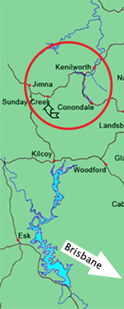
The recommended access route is via Kilcoy as is indicated on the map below and to the right. The turn-off to Sunday Creek is approximately 36 kilometres North of Kilcoy. It is a further 7 kilometres into the campsite with the turn off sign posted 'Kenilworth—Sunday Creek Field Study Centre'. The trip from Kilcoy to Sunday Creek EEC takes approximately 50 minutes - 1 hour.
Google maps will find the centre, however will not navigate to the centre for you. Be assured that once you’ve found Sunday Creek road, you’re on the right track and it’s only 7 kilometres along dirt roads to the centre.
Access roads via Kilcoy are suitable for coaches and small busses however there are smooth dirt roads to negotiate.
The alternative route or back way (from Kenilworth to Sunday Creek) is not suitable for coaches or two wheel drive (2WD) vehicles. Please contact us if you are intending on travelling on this road, or if you have any concerns or queries.
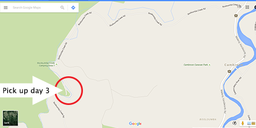
Wilderness treks
Please note that wilderness treks start at Sunday Creek campsite (via Kilcoy), but finish at Booloumba Creek day use area 2, which can be accessed from the Kennilworth side of the National Park. Please refer to the map below.
Ideally students should arrive at the centre before 10am, especially in Winter with limited daylight. Students usually finish the wilderness trek by 12.30pm—1.00pm on day three of their trek.